I can see it, this park connects to that slanted building: remnants of the mission railroad
The other day I was reading in the Juri Commons, the odd, slanted mini-park between 25th and 26th, Guerrero and San Jose, reading when the little map in my head made the straight-line connection to the slanted building at 24th and Capp near where I used to live. I remember talking to someone that suggested it might have been an old railroad route.
I looked into it more and found a cool graphic depiction of the route through the Mission, SoMa and Noe Valley, and some history. It used to be the San Francisco and San Jose Railroad which was later acquired by Southern Pacific. It’s essentially now Caltrain but they added the shortcut tunnels through the hills that made this Bernal cut, as they called it, obsolete. It seems the tracks were taken out sometime between 1906 and 1942–probably in stages.
There are some sites with some cool vintage photos, like this one with Harrison Street tracks, this one of the depot at 3rd and Townsend and this one already linked above.
What I did over the last week was walk along the path, at least in the Mission part. There are still a lot of remnants in angled buildings, rights-of-way and oddly shaped plots. I made the map above. You can see in the satellite view many of the angled buildings. I also took some photos which you can see if you click the placemarkers on the map.
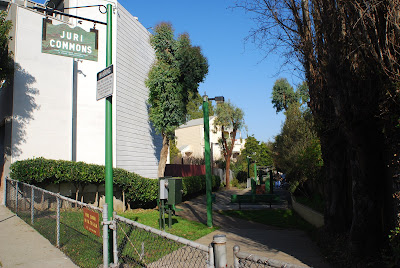
Juri Commons
January 23rd, 2009 at 3:09 pm
This is a pretty sweet map!… It’s sad that they tore down such a beautiful train station, but at least there are some nice photos of it on that other site.
On a side note, last month I was riding down Townsend towards the Caltrain station (in the rain!), and I fell over those damn tracks and totally potato-chipped my back wheel.
January 23rd, 2009 at 4:11 pm
Wow! I live at 22nd & Treat and I can suddenly understand some of the odd building configurations in this area. Very cool. Thanks!
January 23rd, 2009 at 10:45 pm
this is great. thanks.
January 23rd, 2009 at 11:06 pm
[…] Mission Mission also points us to a map of the old Mission railroad. Nice work, […]
January 24th, 2009 at 12:35 pm
Under the central freeway there’s a lot of areas where tracks still pop up above the pavement. In the southeast corner of Best Buy’s parking lot is one example, and an auto body shop across the street has garage doors with rails going in.
January 24th, 2009 at 2:37 pm
That’s cool. I love investigating how the current state of things is influenced by things that are now gone. That’s why I enjoyed Rick Sebak’s Pittsburgh history series so much.
From the map, it looks like there are some new buildings that were built at an angle. I’m guessing that this is because, although the tracks are gone, the lots probably haven’t changed at all in a very long time.
As a side note, after reading about the San Francisco and San Jose Railroad I found myself humming “Do you know the way to San Jose?” by Dionne Warwick/Burt Bacharach. That was totally subconscious.
January 24th, 2009 at 3:40 pm
Sarah and Kevin, you’re welcome.
Eric, I’ll have to check that part of town out, particularly the Best Buy and body shop.
Colin, yeah, I think that a lot of the lots were shaped by the old rights-of-way.
January 27th, 2009 at 4:49 pm
I too am interested in the old mission rail lines and forgotten street plans.
Check this out – if you look at boogaloos from the air, the north side of the building seems to follow some forgotten road or rail line: http://tinyurl.com/boogaloosmap
and if you extend that line east, it goes right into the Giant Value parking lot.
I wonder if this has something to do with the end of San Jose ave (at 22nd). San Jose avenue was built parallel to some tracks – I wonder if those tracks yanked east around 22nd street (behind the hiberian bank, across valencia to mission just on the north side of boogaloos. If you look at the houses in this area, the houses that would be in this path are newer (still old, but definitely not liberty hill vintage). Spork (formerly KFC) and the Thomas Harvey realestate building could be considered in this path. anyways, this is just food for further investigation.