I can see it, this park connects to that slanted building: remnants of the mission railroad
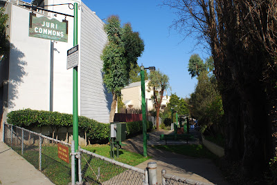
The other day I was reading in the Juri Commons, the odd, slanted mini-park between 25th and 26th, Guerrero and San Jose, reading when the little map in my head made the straight-line connection to the slanted building at 24th and Capp near where I used to live. I remember talking to someone that suggested it might have been an old railroad route.
I looked into it more and found a cool graphic depiction of the route through the Mission, SoMa and Noe Valley, and some history. It used to be the San Francisco and San Jose Railroad which was later acquired by Southern Pacific. It’s essentially now Caltrain but they added the shortcut tunnels through the hills that made this Bernal cut, as they called it, obsolete. It seems the tracks were taken out sometime between 1906 and 1942–probably in stages.
There are some sites with some cool vintage photos, like this one with Harrison Street tracks, this one of the depot at 3rd and Townsend and this one already linked above.
What I did over the last week was walk along the path, at least in the Mission part. There are still a lot of remnants in angled buildings, rights-of-way and oddly shaped plots. I made the map above. You can see in the satellite view many of the angled buildings. I also took some photos which you can see if you click the placemarkers on the map.
Juri Commons